Jacques-Nicolas Bellin
Pozzuoli, Bay of Naples, 1764
9 ½ x 7 ½ in
24 x 19 cm
24 x 19 cm
IT3507
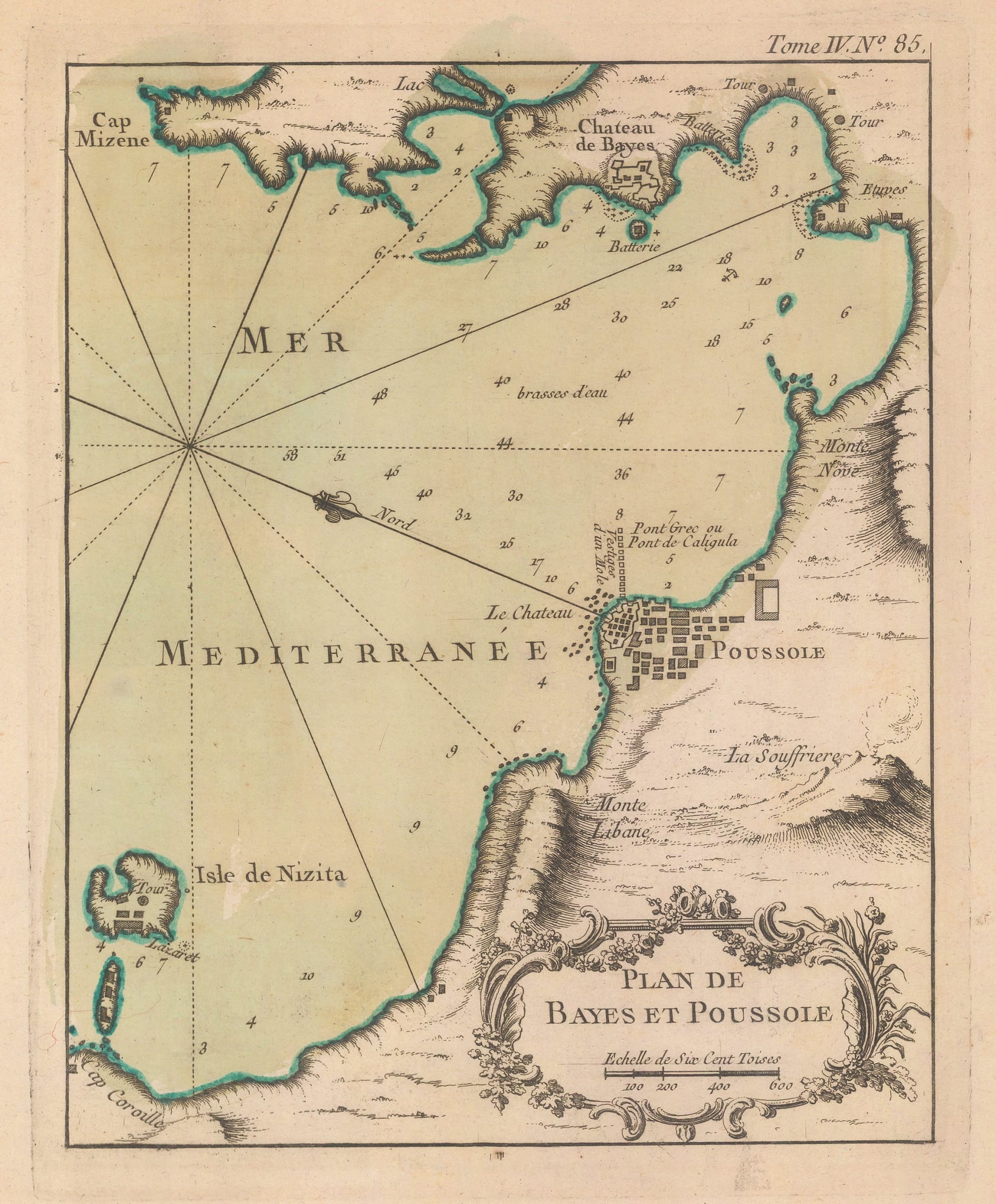
Plan de Bayes et Poussole Small chart of the Bay and harbour of Pozzuoli, within the much larger Bay of Naples. The Isle of Nisida is shown as separate...
Plan de Bayes et Poussole
Small chart of the Bay and harbour of Pozzuoli, within the much larger Bay of Naples. The Isle of Nisida is shown as separate from the mainland although it is now connected.
Jacques-Nicolas Bellin was one of the greatest 18th century map makers. He specialised in hydrography and was appointed to the French Hydrographic office at the young age of 18 in 1721. Twenty years later he was named the first “Ingenieur de la Marine” for the “Depot des Cartes et Plans de la Marine” as well as Hydrographer to Louis XV of France. Over a fifty year career, he published a multitude of important maps often from first hand sources provided by naval officers, merchants and government sources. His level of access was extraordinary. As well as publishing his own atlases, he was a contributor to many seminal French works on exploration, including Abbee Raynal’s “Histoire des Deux Indes”, Abbee Prevost’s “Histoire Generale des Voyages” and Pierre de Charlevoix’s “Histoire et Description Generale de la Nouvelle France”.
In 1762, Bellin decided to publish one of his most popular and accessible works: “Le Petit Atlas Maritime”. The work came out in 1764 in five volumes and proved extremely popular. Many of the maps were reduced versions which Bellin had either contributed or published previously. The five volumes usually contain between 575 and 590 maps with variations noted between individual examples. As the preparation took only two years, it is very likely that Bellin had a majority of these copper plates already available. The initial financial support for the atlas was from Etienne-Francois, Duc de Choiseul, a highly placed French politician who was credited for strengthening both the army and navy. Due to its accessibility, he perceived the ”Petit Atlas Maritime” as a method of publicising both the work of the “Depot de la Marine” and the Navy to the general public. Bellin includes a long dedication to Choiseul on the front of each volume.
For collectors today, the work presents one of the widest selection of extremely desirable smaller maps. They provide clear, concise and attractive geographical records of some of the most inaccessible and exotic areas of the world in the mid-18th century. Bellin was part of a group called “Les Philosophes”, the French counterpart to the pioneers of the English Age of Reason and his maps are a lasting legacy from the Age of French Enlightenment.
The Bay and City of Puzzuoli, part of the Bay of Naples, has been the subject of many maps. It was the major trading port of ancient Rome before the development of Ostia by the Emperors Claudius and Nero in the mid 1st century AD. Nicolas de Fer, Jacques Ayrouard and Bellin are among the many 18th century map makers who produced maps of the Bay. Most of these maps feature the famous or infamous “Caligula’s Bridge” when the emperor commanded a temporary bridge of floating trade ships to be arranged across the Bay to the settlement of Baiae or Chateau de Bayes on this map. It stretched over two miles and Caligula rode over it after an astrologer had predicted that “he had as much chance to become emperor as he had of riding a horse across the Bay of Baiae.”
The map is oriented with north shown to the upper left of the sheet.
Original colour. [IT3507]