Jacques-Nicolas Bellin
The First Obtainable Map of Detroit, 1764
8 ½ x 13 in
22 x 33 cm
22 x 33 cm
USA9407
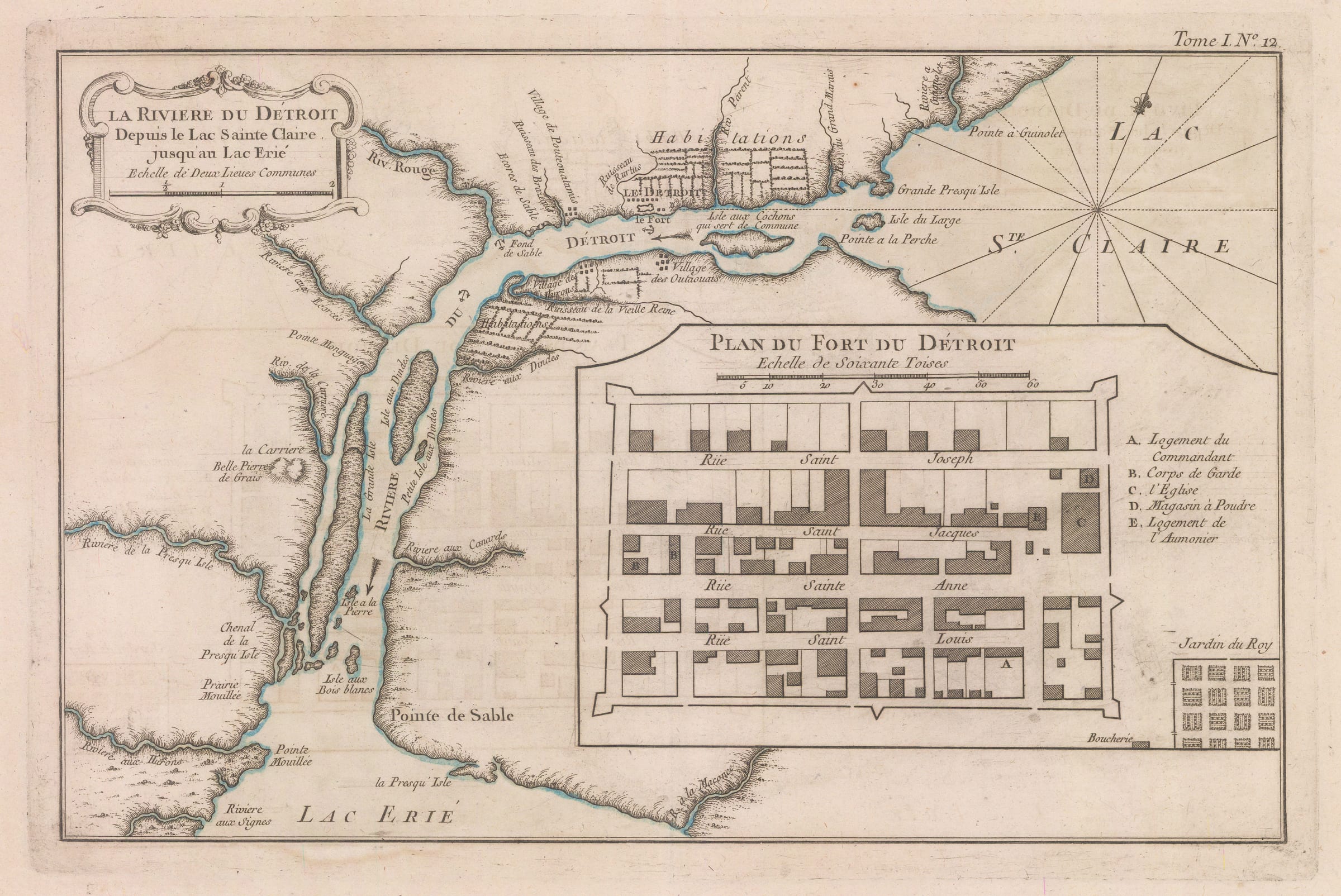
La Riviere du Detroit Celebrated map of the Detroit River between Lakes Erie and St. Clair. The inset of the Fort du Detroit is the first cartographic representation of...
La Riviere du Detroit
Celebrated map of the Detroit River between Lakes Erie and St. Clair. The inset of the Fort du Detroit is the first cartographic representation of Detroit.
Jacques-Nicolas Bellin was one of the greatest 18th century map makers. He specialised in hydrography and was appointed to the French Hydrographic office at the young age of 18 in 1721. Twenty years later he was named the first “Ingenieur de la Marine” for the “Depot des Cartes et Plans de la Marine” as well as Hydrographer to Louis XV of France. Over a fifty year career, he published a multitude of important maps often from first hand sources provided by naval officers, merchants and government sources. His level of access was extraordinary. As well as publishing his own atlases, he was a contributor to many seminal French works on exploration, including Abbee Raynal’s “Histoire des Deux Indes”, Abbee Prevost’s “Histoire Generale des Voyages” and Pierre de Charlevoix’s “Histoire et Description Generale de la Nouvelle France”.
In 1762, Bellin decided to publish one of his most popular and accessible works: “Le Petit Atlas Maritime”. The work came out in 1764 in five volumes and proved extremely popular. Many of the maps were reduced versions which Bellin had either contributed or published previously. However, there are some notable exceptions, such as his famous map of Manhattan, which was sourced from a manuscript map by J.B.L. Franquelin drawn in 1693. The five volumes usually contain between 575 and 590 maps with variations noted between individual examples. As the preparation took only two years, it is very likely that Bellin had a majority of these copper plates already available. The initial financial support for the atlas was from Etienne-Francois, Duc de Choiseul, a highly placed French politician who was credited for strengthening both the army and navy. Due to its accessibility, he perceived the ”Petit Atlas Maritime” as a method of publicising both the work of the “Depot de la Marine” and the Navy to the general public. Bellin includes a long dedication to Choiseul on the front of each volume.
For collectors today, the work presents one of the widest selection of extremely desirable smaller maps. They provide clear, concise and attractive geographical records of some of the most inaccessible and exotic areas of the world in the mid-18th century. Bellin was part of a group called “Les Philosophes”, the French counterpart to the pioneers of the English Age of Reason and his maps are a lasting legacy from the Age of French Enlightenment.
Unlike many of the maps from the atlas, this record of the River Detroit made its first appearance in this work and the large inset of the fort is the first recorded plan of what became the city of Detroit. The map was based on surveys provided by Chaussegros de Lery, a French military engineer noted for his gallantry in the Seven Years War. De Lery in turn had access to the legendary maps of western Canada and the Great Lakes made by Sieur de Verendry although it is impossible to state if de Lery made copies of the maps or integrated them into his surveys.
This is a key map in the study of the cartographic history of the Great Lakes.
Original colour.