Willem & Jan Blaeu
Nova Totius Terrarum Orbis Geographica Ac Hydrographia Tabula, 1640 c.
16 ½ x 21 ½ in
42 x 55 cm
42 x 55 cm
WLD3786
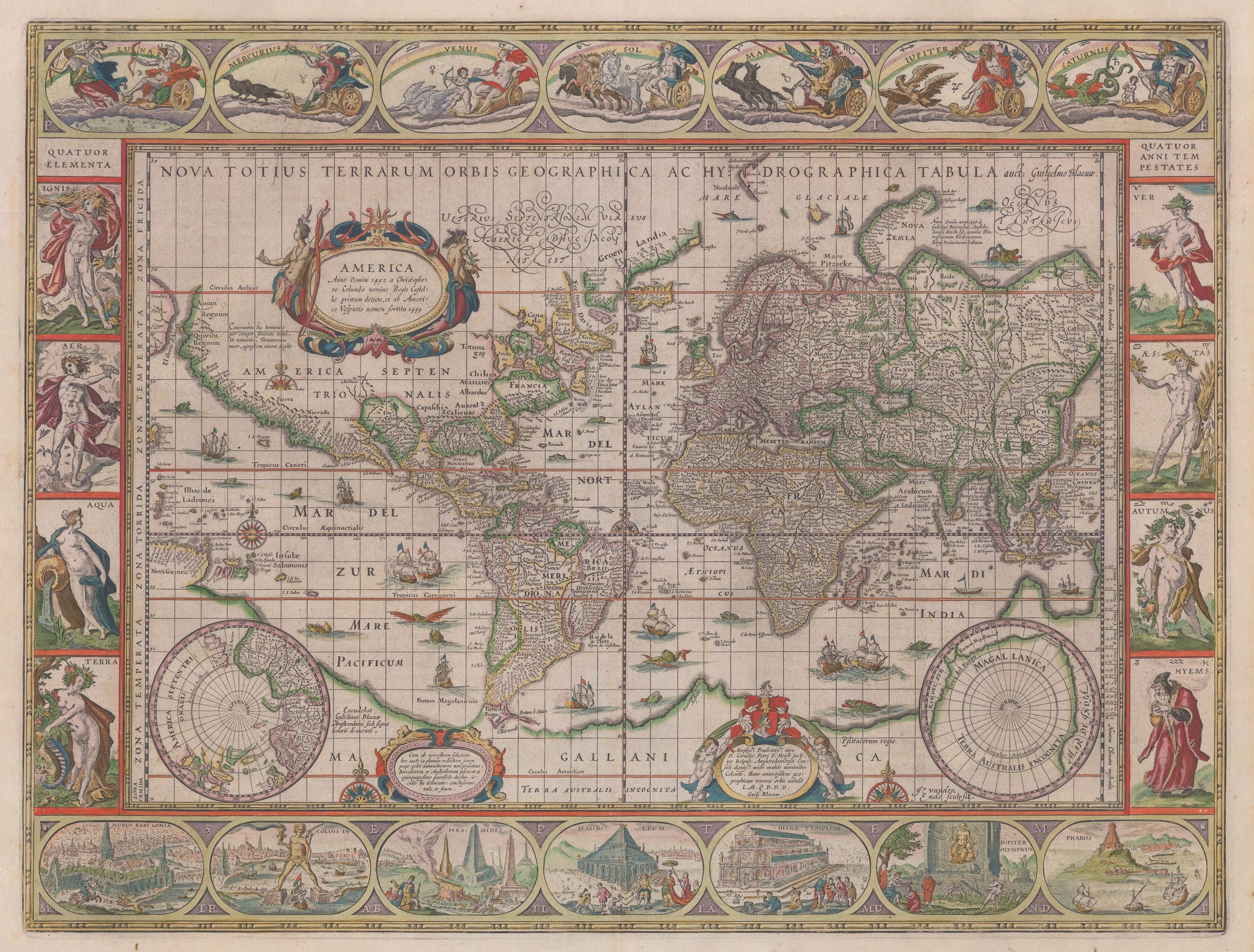
Willem Blaeu’s map on Mercator’s projection is one of the most iconic cartographic images of the Dutch Golden Age of Cartography, a period acknowledged as the epoch in which geography...
Willem Blaeu’s map on Mercator’s projection is one of the most iconic cartographic images of the Dutch Golden Age of Cartography, a period acknowledged as the epoch in which geography and art enjoyed a practically seamless merger. This image was used as an archetype for centuries and is still used for the same purpose today.
Geographically, it is a reduction of Willem Blaeu’s own wall map published in 1605. It was issued as a separate sheet in 1606 both commercially but also no doubt as a very effective piece of promotion for the wall map; and also for the promotion of the future accompanying set of matching continental maps of Europe, America, Asia and Africa which were in preparation both in wall map form and as separately issued folio sheets.
Geographically, as stated above, the map is based on Blaeu’s own wall map; in turn this map is fundamentally based on Mercator’s 1569 map of the world although now with substantial updates from the recently discovered Hondius wall map of c.1603. Reports of new geographical discoveries were reaching Europe and especially Amsterdam with dizzying rapidity during the late 16th century, reflected by some radical changes recorded on this map. One of the greatest areas of activity was the Northeast coast of North America where English explorers such as Martin Frobisher and John Davis were already searching for the Northwest Passage. The map tries to reconcile the vexing nature of Greenland together with the exact position of “Terra Labrador” the discovery of which is from a much earlier generation of voyages in 1498. This leads to the portrayal of a veritable archipelago in that region.
Whether by accident or design the west coast is remarkably accurate, showing California as a Peninsula and a straight coast albeit marking several legendary regions or cities such as Quivira and Anian. The shape of the New World is most reminiscent of the world maps by Petrus Plancius of 1590 and 1594. The shape of the other three continents is reminiscent of Mercator, although the shape of China, Japan and the island of Korea is derived from Ortelius. South East Asia is again derived from Plancius who in turn took his information from Bartolomeu Lasso’s Portuguese charts.
After a long and successful commercial run as a separate issue, this map was initially inserted into Willem Blaeu’s “Appendix” in 1630. Following that successful publication, it was then used as the world map in the “Atlas Novus” in 1635 which grew to six volumes and was issued in multiple languages. It was not replaced until 1658. It remained fundamentally unchanged for these 52 years with the exception of the addition of the Le Maire Straits as a new route around Cape Horn in South America which appeared in the atlas editions. It was imitated by many of Blaeu’s cartographic contemporaries such as Pieter van den Keere and Jan Jansson well into the later 17th century.
Of equal importance to the geography are the aesthetics of this map. While the concept of figurative decorations on the borders of maps goes back as far as 1532 when Hans Holbein the Younger provided a series of images for the border of Sebastian’s Munster’s world map, this concept and idea had been taken to a new level by Petrus Plancius on his map of 1594. Blaeu in turn emulated Plancius and for the first time used a figurative border on a world map on Mercator’s Projection. The upper border shows representations of heavenly bodies; the left border does the same for the elements while the right does so for the seasons. The lower border is a tribute to the classical world with a series of images detailing and naming the Seven Wonders of the Ancient World.
It would be fair to say that while Blaeu’s map was often emulated and sometimes equalled, it would be difficult to quote an instance where it was surpassed.
Original hand colour. [WLD3786]