Abraham Ortelius
51 x 38 cm
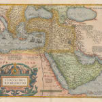
There are multiple important accolades that should be given to this map. It is the first commercially available printed map to showcase the Ottoman Empire. It is the first printed map to show Suleiman the Magnificent’s conquests in Europe and Asia. It is the first commercially available map to bear the title “The Turkish Empire”. Finally, its very existence is politically charged when put in context to its time and place of publishing.
The map was first issued in Abraham Ortelius’s “Theatrum Orbis Terrarum”. Published in 1570, this was the first curated book of uniformly sized, engraved and geographically organised maps. It is universally perceived as the first modern Atlas.
Geographically, the map is almost exclusively based on Giacomo Gastaldi’s four sheet map of Asia published 1559-61. It is very likely that Gastaldi in turn obtained the information from Giovanni Battista Ramusio, Secretary to the powerful Venetian Council of Ten.
Ortelius uses Gastaldi’s geography but adds a new dimension by showcasing the recent conquests of arguably the greatest of the Ottoman Emperors, Suleiman I also called the Magnificent. These include the capture of the key fortress of Belgrade, the conquest of a large part of Hungary and the island of Rhodes in Europe; in Asia, in a series of campaigns against the Safavid Persians, he conquered most of modern Iraq, including the city of Baghdad, gained access to the Persian Gulf and came to an agreement for the partition of the Caucasus. To these he added the fortress of Aden in Yemen, combining it with the Ottoman possession of the eastern coast of Arabia conquered by his father Selim I. This newly expanded Empire became not only the dominant power in the Middle East, but one of the dominant powers in the world.
The geo political aspect of this map is significant. Its geographical extent is determined by these new conquests, from the Austro-Hungarian border to the new borders of Persia and from the Indian Ocean to the northern Caucasus. In Europe, Suleiman’s main antagonist was the Hapsburg Empire. Indeed, when Suleiman defeated the Hungarian ruling dynasty in 1526 at the Battle of Mohacs, it was Ferdinand I, Holy Roman Emperor who stepped in to try and prevent Turkish control. Later campaigns swung back and forth but ultimately ended with Ferdinand having to pay tribute to Suleiman for the lands he held in western Hungary after the siege of Buda and later peace talks in 1547.
Antwerp in 1570 was one of the great cities of the Spanish Netherlands and a Hapsburg possession; it and the region were also in revolt against the House of Hapsburg. Indeed one of the reasons why the Hapsburg Empire had such difficulty in dealing with the Dutch Revolt was due to continued Turkish invasions from the East; yet Ortelius was publishing a map showing the extent of the most recent Turkish successes, including several against the House of Hapsburg. The text on the reverse does mitigate the map somewhat, by describing the terror and brutality of the Ottoman emperors, yet the initial impact of the face of the map cannot be denied.
Ortelius’s map was hugely influential. The great Dutch publishing houses of the 17th century generally included a map of the Turkish or Ottoman Empire in their atlases, copying the geographical extent and layout of this map. Map makers in Paris, London and Rome followed suit and this geographical model lasted well into the 18th century.
There are two known versions or states of this map. Cartographically, they do not change but the cartouche is redesigned after 1579. Our example is a 1592 edition in original hand colour. Latin text on verso.
[Marcel van den Broecke "Ortelius Atlas Maps, An Illustrated Guide" 2nd Edition: Ort 169]


