-
 Matthaus Albrecht Lotter, Mappemonde ou Carte Generale de L'Univers, 1778£ 3,850.00
 -
John Blair, A Map of the World, 1779 c.£ 1,575.00
-
J.C. & J.A. Dezauche, Planisphere Physique, 1780£ 1,150.00
-
Jacques-Nicolas Bellin, Carte Reduites des parties connues du Globe Terrestre, 1784£ 3,750.00
-
Andrew Bell, A Map of the World in Three Sections describing the Polar Regions to the Tropics, 1784£ 445.00
-
Tardieu, Mappe Monde, 1785£ 175.00
-
-
Charles Cooke, The World including the Discoveries made by Captain Cook, 1790 c.£ 795.00
-
Laurie & Whittle, A New Chart of the World with The Tracks & Discoveries of the Latest Circumnavigators, 1794£ 1,150.00
-
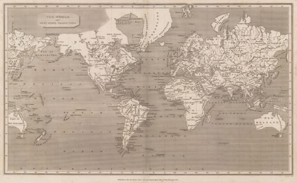
Sir George Staunton, A General Chart on Mercator's Projection, 1796£ 1,450.00
-
William Faden, The New World and the Old World, 1798£ 525.00
-
Charles Francois Delamarche, Mappe-Monde, 1800 c.£ 365.00
-
John Cary, A New Chart of The World, 1801£ 1,450.00
-
William Guthrie, Chart of the World on Mercator's Projection, 1801£ 145.00
-
-
Aaron Arrowsmith, The World from the Latest Voyages & Travels, 1802£ 185.00
-
William Faden, Western Hemisphere & Eastern Hemisphere, 1802£ 2,750.00
-
-
-
-
-
-
Jean-Baptiste-Louis Clouet, Mappemonde ou Globe Terestre, 1807£ 2,500.00
-
Aaron Arrowsmith, The World on Mercators Projection, 1807£ 395.00
-
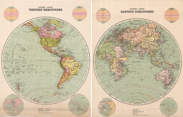
John Pinkerton, [Western Hemisphere - Eastern Hemisphere], 1812£ 1,250.00
-
Conrad Malte-Brun, Mappe-Monde sur la Projection Reduite de Mercator, 1812£ 195.00
-
C.V. Lavoisne, Geographical Map of the World, 1813£ 425.00
-
John Pinkerton, The World on Mercator's Projection, 1814 c.£ 2,250.00
-
-
Stanislao Stucchi, Mappa-Mondo in due Emisferi, 1820£ 875.00
-
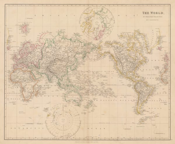
John Thomson, Chart of the World on Mercators Projection, 1820 c.£ 1,250.00
-
John Thomson, Eastern and Western Hemisphere, 1820 c.£ 1,850.00
-
John Thomson, Northern and Southern Hemispheres, 1820 c.£ 1,250.00
-
Thomas Starling, The World, 1830£ 225.00
-
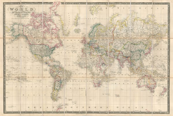
John Arrowsmith, The World, 1835£ 1,150.00
-
Rest Fenner, The World, 1836£ 150.00
-
James Wyld, The World on Mercator's Projection, 1837£ 1,950.00
-
James Reynolds, Geographical Diagram of the Earth Adapted for Illustrating its Movements &c., 1840 c.£ 275.00
-
-
W. & A.K. Johnston, Chart of the World on Mercator's Projection, 1844£ 575.00
-
James Gilbert, Map of the World on Mercator's Projection, 1844£ 4,850.00
-
Joseph Meyer, Welt-Karte in Mercators Projektion, 1844£ 275.00
-
Victor Levasseur, Planisphere, 1847£ 650.00
-
Richard Holmes Laurie, The World on Mercator's Projection, 1850£ 2,750.00
-
James Reynolds, Geological Map of the World, 1850 c£ 545.00
-
Abe Yoshito, Japanese Map of the Eastern and Western Hemisphere, 1850 c.£ 845.00
-
Joseph Meyer, Erd-Karte, 1850 c.£ 185.00
-
John Tallis, Western and Eastern Hemisphere, 1851£ 1,150.00
-
Abe Yasuyuki, Japanese Map of the World, 1853£ 845.00
-
-
Matthew Perry, Chart of the World, 1856£ 950.00
-
Archibald Fullarton, British Empire Throughout the World Exhibited in One View, 1860 c.£ 2,250.00
-
John Dower, [Eastern & Western Hemisphere], 1860 c.£ 225.00
-
-
-
Samuel Augustus Mitchell, Map of the World on the Mercator Projection, 1866£ 345.00
-
Julius Maier, Neueste Karte der Erde, 1870 c.£ 2,650.00
-
Justus Perthes, Chart of the World on Mercators Projection, 1871£ 3,250.00
-
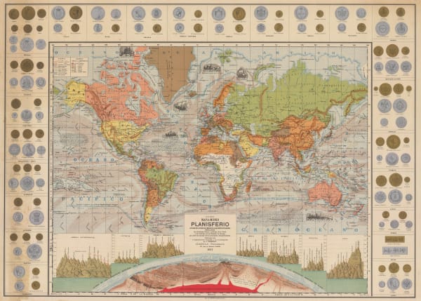
Jules Marcou, Geological Map of the World, 1875£ 4,250.00
-
-
James Wyld, The World on Mercator's Projection, 1877£ 395.00
-
-
James Wyld, The World on Mercator's Projection, 1882 c.£ 1,950.00
-
Illustrated London News (ILN), The World showing the British Possessions and Chief Ports, 1885£ 595.00
-
-
George Philip & Son Ltd., The World on the Plane of a Meridian, 1890£ 245.00
-
George W. Bacon, The World, 1890 c.£ 155.00
-
Alexander Gleason, Gleason's "Flat Earth" Map, 1892£ 4,950.00
-
Rand, McNally & Co., Rand McNally & Co's Map of the World, 1901£ 985.00
-
Edward Stanford, A Chart of the World on Mercator's Projection, 1903£ 1,450.00
-
George W. Bacon, New Chart of the World, 1909 c.£ 2,950.00
-
George Philip & Son Ltd., The British Empire showing the Great Commercial Highways, 1910 c.£ 295.00
-
J. Dosseray, Nuevo Mapa-Mundi Planisferio, 1911£ 3,500.00
-
J. Nystrom, Eastern and Western Hemispheres, 1914£ 3,500.00
-
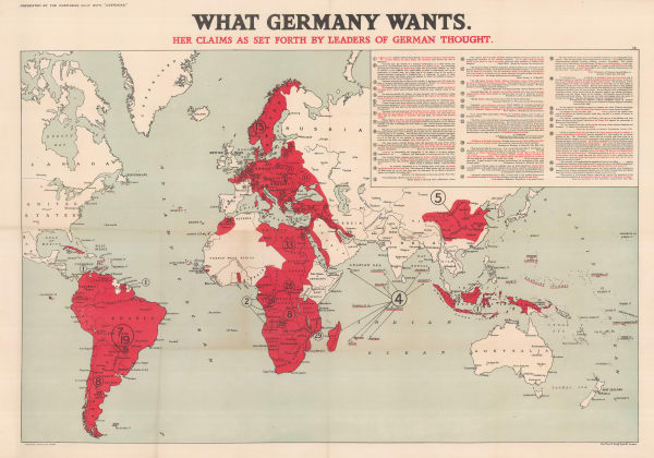
Edward Stanford, What Germany Wants, 1916£ 1,650.00
-
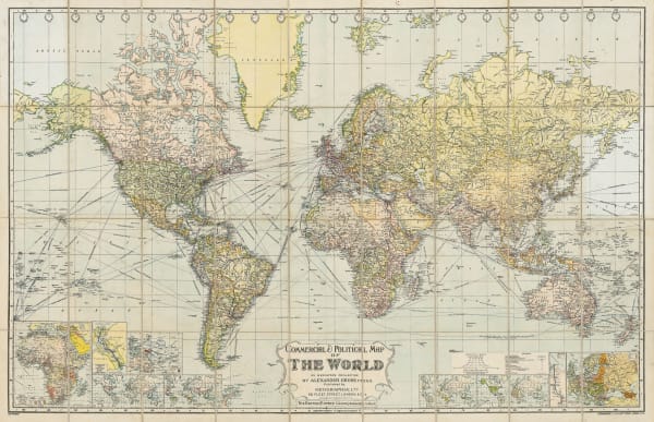
Alexander Gross, Commercial & Political Map of the World, 1920£ 4,950.00
-
Geographia Ltd., The World - Time Zones, Cables & Wireless Stations, 1920 c.£ 275.00
-
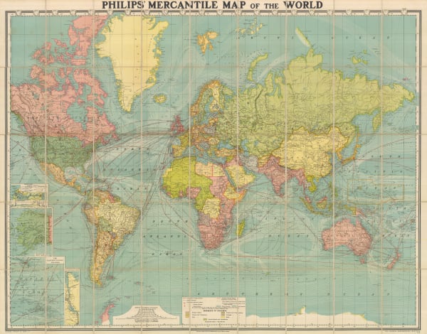
George Philip & Son Ltd., Mercantile Map of the World, 1925 (c.)£ 1,650.00
-
Waterlow & Sons, Map of the World showing British Empire and the Eastern Associated Telegraph Companies' Cable System, 1925 c.£ 125.00
-
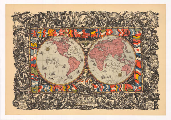
James Daugherty, This World of Ours, 1929 c.£ 2,500.00


![John Pinkerton, [Western Hemisphere - Eastern Hemisphere], 1812](https://artlogic-res.cloudinary.com/w_600,c_limit,f_auto,fl_lossy,q_auto/artlogicstorage/themaphouse/images/view/be9fc1bd6701b9daa2e5b0a91c28b129j/themaphouse-john-pinkerton-western-hemisphere-eastern-hemisphere-1812.jpg)


![John Dower, [Eastern & Western Hemisphere], 1860 c.](https://artlogic-res.cloudinary.com/w_600,c_limit,f_auto,fl_lossy,q_auto/artlogicstorage/themaphouse/images/view/57db0388eaf308be7b86bde5d18fca11j/themaphouse-john-dower-eastern-western-hemisphere-1860-c..jpg)


Page
2
of 3