-
 Tobias Conrad Lotter, Sinarum Imperium, 1750 c.£ 1,750.00
 -
Jacques-Nicolas Bellin, Plan de Jedo, 1752£ 545.00
-
J.B.B. D'Anville, Seconde Partie de la Carte D'Asie. Continent La Chine et partie de la Tartarie, L'Inde au dela du Gange, Les Ilses: Sumatra, Java, Borneo, Moluques, Philippines, et du Japon, 1752£ 1,500.00
-
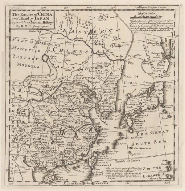
Herman Moll, The Empire of China and the Island of Japan, 1755 c.£ 625.00
-
Jacques-Nicolas Bellin, Carte des Isles du Japon Et la Presqu'Isle de Coree, 1760 c.£ 625.00
-
Jacques-Nicolas Bellin, Karte von der Einfahrt des Flusses Canton, 1760 c.£ 275.00
-
Isaac Tirion, Nouvelle Carte de L'Empire de la Chine, 1760 c.£ 825.00
-
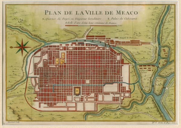
Jacques-Nicolas Bellin, Plan de la Ville Meaco, 1762£ 595.00
-
Jacques-Nicolas Bellin, Carte de L'Empire du Japon, 1764£ 885.00
-
Jacques-Nicolas Bellin, Carte des Isles qui sont a l'entree de la Riviere de Canton, 1764£ 195.00
-
Jacques-Nicolas Bellin, Isle de Cheu-Chan ou Isle Chusan, 1764£ 125.00
-
Emanuel Bowen, A New and Accurate Map of the Empire of Japan, 1766£ 2,450.00
-
Rigobert Bonne, Carte de la Tartarie Chinoise, 1771£ 265.00
-
Jean-Baptiste de Mannevillette, Carte d'une partie de cotes de la Chine, 1775£ 3,750.00
-
Francois Santini, L'Empire De La Chine, avec La Tarttarie Chinoise, 1779£ 645.00
-
Rigobert Bonne, L'Empire de la Chine, 1780 c.£ 295.00
-
Antonio Zatta, L'Impero Del Giapon, 1785£ 1,650.00
-
Robert de Vaugondy, L'Empire de la Chine, 1790 c.£ 425.00
-
Laurie & Whittle, A Chart of the Northern Part of the China Sea, 1794£ 2,450.00
-
Laurie & Whittle, A Survey of the Tigris, 1794£ 4,250.00
-
Antonio Zatta, Impero della China, 1795£ 725.00
-
Sir George Staunton, A Chart of the Islands to the Southward of Tchu-San on the Eastern Coast of China, 1796£ 295.00
-
Sir George Staunton, A Chart on Mercator's Projection Containing the Track and Soundings of the Lion, the Hindostan and Tenders, from Turon-Bay in Cochin China to the Mouth of the Pei-Ho River in the Gulph of Pe-Tche-Lee or Pekin, 1796£ 725.00
-
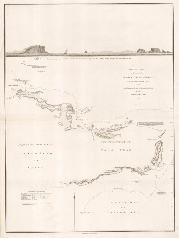
Sir George Staunton, A Sketch by Compass of the Coast of the Promontory of Shan-Tung with the track of the ships and the Soundings from the place of first making the Land to the Strait of Mi-a-Tau, 1796£ 285.00
-
Sir George Staunton, A Sketch of a Journey from Zhe-Hol in Tartary by Land to Pekin and from thence by water to Hang-Tchoo-Foo in China, 1796£ 985.00
-
Jean Francois de La Perouse, Carte des Decouvertes, 1797£ 220.00
-
Jean Francois de La Perouse, Lapérouse's Discoveries in China, Taiwan, Japan & Korea, 1797£ 495.00
-
Jean Francois de La Perouse, Lapérouse's Discoveries in China, Taiwan, Japan & Korea, 1797£ 675.00
-
William Faden, China and Chinese Tartary, 1798£ 295.00
-
Adolf Stieler, Charte von China, 1804£ 595.00
-
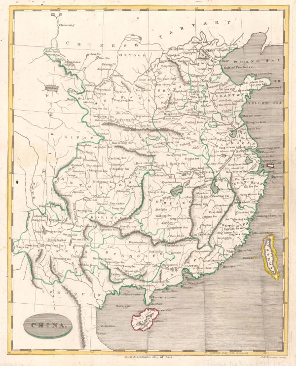
Morse and Andrews, China, 1805£ 225.00
-
Christian Louis Jose De Guignes, Carte de L'Entre de Macao, 1808£ 2,450.00
-
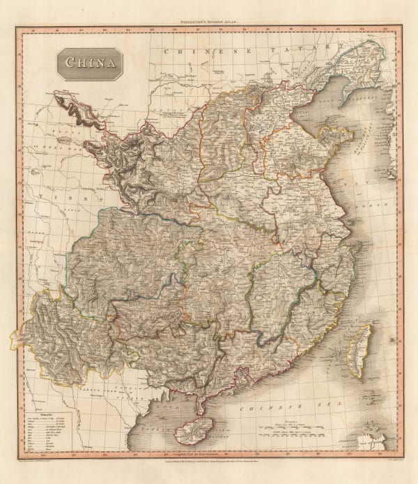
John Pinkerton, China, 1809£ 495.00
-
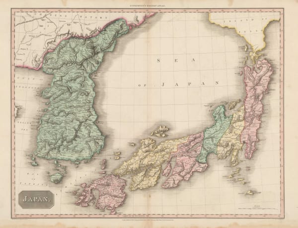
John Pinkerton, Japan, 1809£ 1,250.00
-
Jean-Baptiste-Marie Chamouin, Empire Chinois et Japon, 1810 c.£ 245.00
-
William Guthrie, China: From the Best Authorities, 1812£ 94.00
-
C.V. Lavoisne, Geographical and Historical Map of China, 1813£ 525.00
-
John Thomson, China, 1815£ 425.00
-
Bartolomeo Borghi, L'Impero Della China E L'Impero Del Giappone, 1818£ 285.00
-
Daniel & William Lizars, China, 1820 c.£ 345.00
-
John Thomson, Corea and Japan, 1820 c.£ 1,545.00
-
Philippe Vandermaelen, China - Beijing, Tiānjīn and Hebei, 1827£ 750.00
-
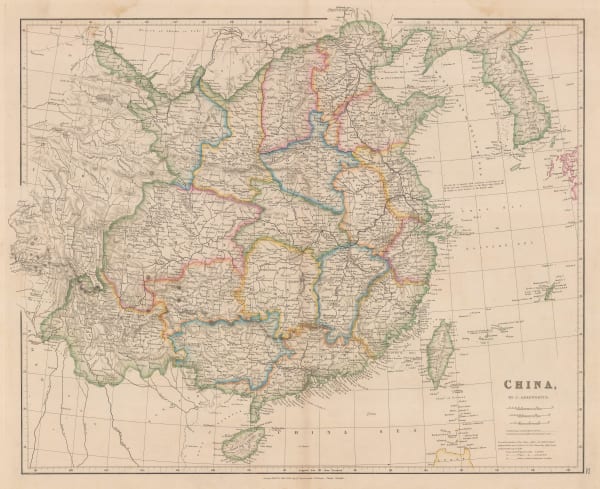
John Arrowsmith, China, 1832£ 695.00
-
Carl Weiland, Das Chinesische Reich und das Kaiserthum Japan, 1832£ 345.00
-
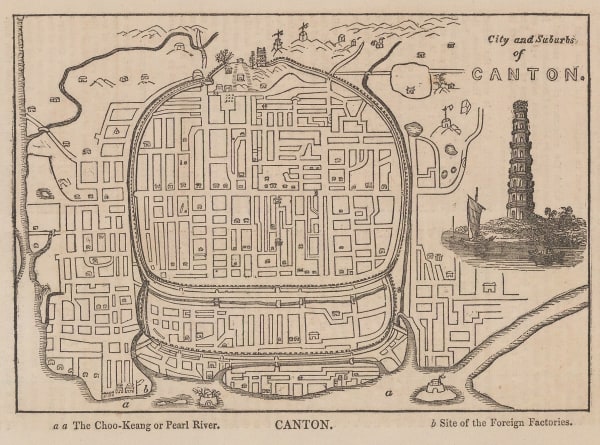
Anonymous, City and Suburbs of Canton, 1835£ 48.00
-
Alexandre Emile Lapie, Carte de L'Empire Chinois et du Japon, 1838£ 185.00
-
Thomas Kelly, China, 1840 c.£ 92.00
-
Anonymous, Tempo Period Map of Tokyo, 1840 c.£ 1,850.00
-
Henry Teesdale, China and Japan, 1841£ 395.00
-
Samuel Augustus Mitchell, China, 1849£ 295.00
-
Joseph Meyer, China-Propria - oder das eigentliche - China, 1849£ 115.00
-
Peter Jackson, China, 1850 c.£ 92.00
-
James Wyld, Map of China, 1850 c.£ 1,350.00
-
Gall & Inglis, Map of China and Japan, 1850 c.£ 165.00
-
John Tallis, China and Birmah, 1851£ 395.00
-
John Tallis, Japan & Corea, 1851£ 695.00
-
John Tallis, Thibet, Mongolia, and Manchouria, 1851£ 295.00
-
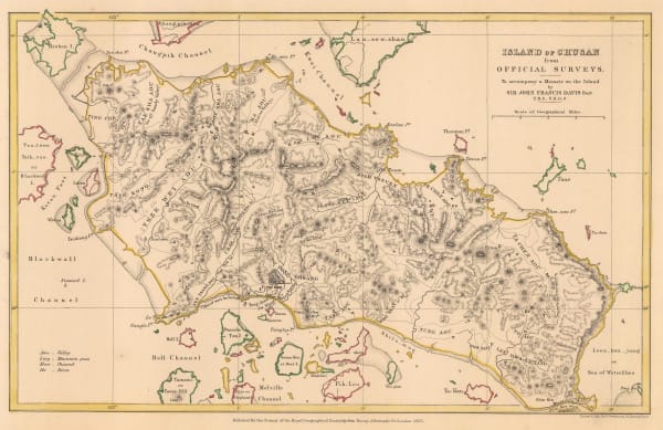
Royal Geographical Society (RGS), Island of Chusan from Official Surveys, 1853£ 85.00
-
Matthew Perry, Keelung Harbor - Formosa Island, 1854£ 1,275.00
-
Royal Geographical Society (RGS), Map of the Amur and Adjacent Districts, 1858£ 225.00
-
Justus Perthes, Open Trading Ports in China, Japan & the Philippines, 1860£ 125.00
-
-
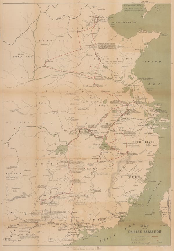
W. & A.K. Johnston, Map of the Chinese Rebellion, 1860£ 1,200.00
-
Justus Perthes, Umgegend von Peking, 1860£ 82.00
-
A. Fullarton & Co., Japan, Mandshuria, the Kurile Isles &c., 1860 c£ 445.00
-
Society for Promoting Christian Knowledge (SPCK), China, 1860 c.£ 195.00
-
Archibald Fullarton, China, 1860 c.£ 285.00
-
John Rapkin, China and Burmah, 1860 c.£ 175.00
-
Royal Geographical Society (RGS), Japan - Map to Illustrate a Journey from the City of Yeddo to the Mountain of Fusi-Yama, 1861£ 245.00
-
Royal Geographical Society (RGS), China - The Yang-Tsze Kiang, 1862£ 375.00
-
Eugène Andriveau-Goujon, East & Southeast Asia, 1862£ 985.00
-
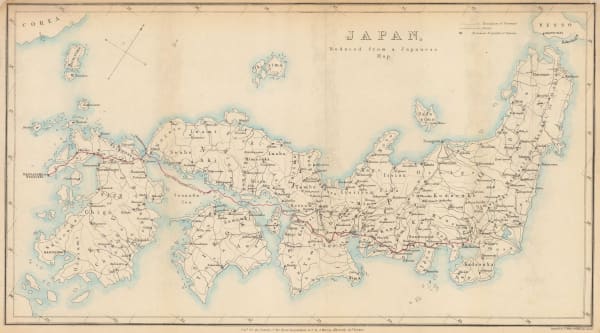
Royal Geographical Society (RGS), Japan, reduced from a Japanese map., 1862 c.£ 275.00
-
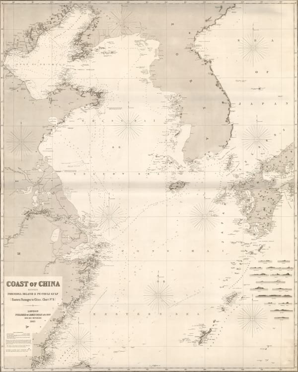
Edward Weller, Coast of China, 1863£ 125.00
-
-
James Imray, East Indian Archipelago. (Eastern Passages to China. Chart No.7), 1863£ 2,200.00
-
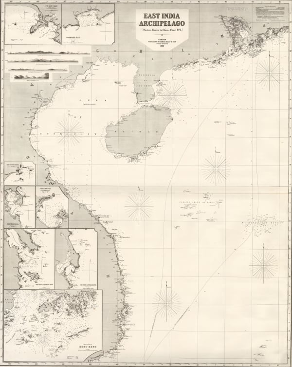
James Imray, East Indian Archipelago. (Western Route to China. Chart No. 5), 1863£ 4,950.00
-
Royal Geographical Society (RGS), Map to Illustrate the Routes of Messrs. Michie & Grant, 1863£ 165.00
-
Royal Geographical Society (RGS), Tsu-Sima Island, 1863£ 88.00
-
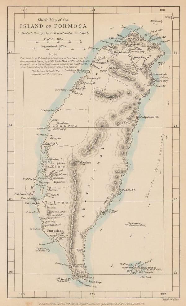
Royal Geographical Society (RGS), Sketch map of the Island of Formosa, 1864£ 425.00
-
Royal Geographical Society (RGS), The City of Peking, 1866£ 675.00


Page
2
of 5