-

-
-
-
Sebastian Münster, Great Britain and Ireland, 1590 c.£ 495.00
-
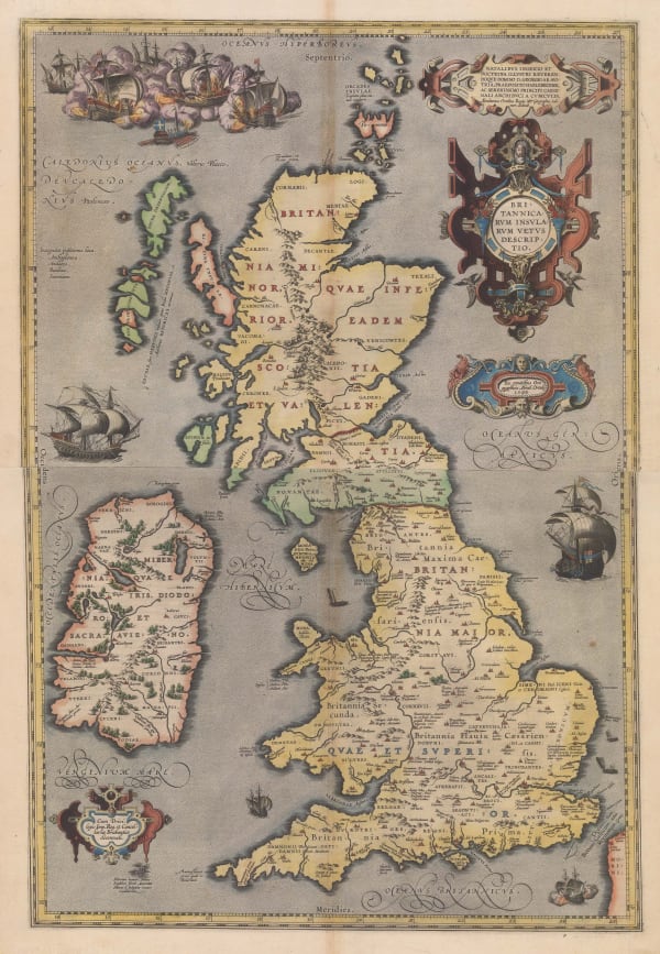
Abraham Ortelius, Great Britain & Ireland in Bright Original Colour, 1592£ 3,850.00
-
Tomaso Porcacchi, Miniature Map of Britain & Ireland, 1604£ 495.00
-
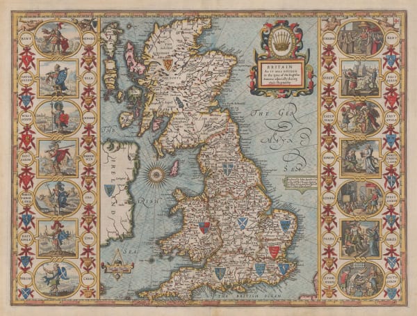
John Speed, The Kingdom of Great Britain and Ireland, 1611£ 4,950.00
-
John Speed, The Kingdome of Great Britaine and Ireland, 1614£ 4,500.00
-
Giovanni Antonio Magini, Miniature Map of Great Britain & Ireland, 1617£ 445.00
-
Petrus Bertius, Miniature Map of the British Isles, 1620 c.£ 445.00
-
Sebastian Münster, Rare Variant of Munster's Map of Britain, 1621£ 1,550.00
-
David Custodis, Uncommon Map of the British Isles, 1627£ 695.00
-
Mercator Hondius, Great Britain & Ireland, 1630£ 475.00
-
Henricus Hondius, Dutch Golden Age Map of Britain, 1642£ 3,750.00
-
Wenceslaus Hollar, Rare Allegorial Map of Britain during the Civil War, 1643 c.£ 4,950.00
-
-
Jan Jansson, Dutch Golden Age Map of Britain, 1648 c.£ 975.00
-
Willem & Jan Blaeu, Dutch Golden Age Map of Britain, 1650 c.£ 1,850.00
-
Jan Jansson, Historical Map of Britain during Roman Times, 1661£ 325.00
-
Richard Blome, A Generall Mapp of the Isles of Brittaine, 1669£ 985.00
-
John Speed, Anglo-Saxon Britain, 1676£ 4,750.00
-
Theodore Danckerts, Kingdom of Great Britain, 1685 c.£ 1,950.00
-
Robert Morden, England Scotland and Ireland, 1688£ 425.00
-
Pieter Schenk, Kingdom of Great Britain, 1690 c.£ 895.00
-
Nicolas Sanson, British Isles, 1700£ 575.00
-
Guillaume De L'Isle, The British Isles, 1702£ 925.00
-
Jean Baptiste Nolin, The British Isles, 1707 c.£ 550.00
-
Johann Baptist Homann, Great Britain & Ireland, 1713 c.£ 895.00
-
Herman Moll, A New Map of Great Britain, 1733 c£ 3,500.00
-
Matthaus Seutter, Tabula Novissima Accuratissima Regnorum Angliae, Scotiae Hiberniae, 1735 c.£ 895.00
-
Mount & Page, A New and Correct Chart of England, Scotland and Ireland, 1740 c.£ 895.00
-
Isaac Tirion, New Map of the British Isles, 1743£ 545.00
-
Elias Baeck, The Kingdoms of England, Scotland & Ireland, 1748£ 395.00
-
Georges-Louis Le Rouge, The British Isles, 1748 c.£ 265.00
-
Homann Heirs, Kingdoms of Great Britain & Ireland, 1749£ 725.00
-
Tobias Conrad Lotter, Great Britain & Ireland, 1755 c.£ 165.00
-
Jacques-Nicolas Bellin, The British Isles, 1764£ 195.00
-
Étienne André Philippe de Prétot, The British Isles, 1767£ 450.00
-
John Cary, A New Map of the British Isles, 1807£ 495.00
-
Robert Rowe, Wall Map of Great Britain and Ireland, 1810£ 975.00
-
C.V. Lavoisne, Geographical and Historical Map of Britain, 1813£ 325.00
-
John Cary, Cary's Reduced Wall Map of Britain, 1818£ 2,200.00
-
Charles Smith, Smith's New Map of the United Kingdom, 1827£ 3,750.00
-
Sidney Hall, British Isles, 1830 c.£ 165.00
-
Edward Mogg, Mogg's Map of Steam Navigation, 1834£ 1,250.00
-
-
Richard Holmes Laurie, Travelling Map of England and Scotland, 1839£ 275.00
-
J. & C. Walker, Map of the British Isles, 1842£ 1,450.00
-
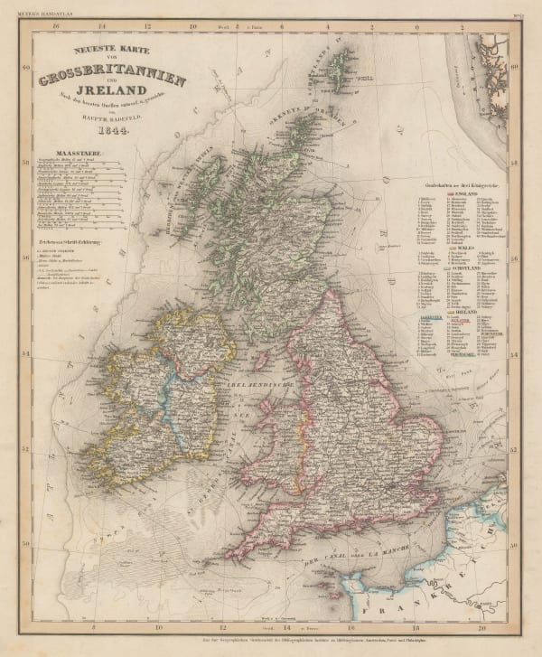
Joseph Meyer, New Map of Great Britain & Ireland, 1844£ 245.00
-
James Wyld, Wall Map of Great Britain & Ireland, 1847£ 1,750.00
-
Alexander Keith Johnston, Paleontological Map of the British Isles, 1850 c£ 395.00
-
-
John Tallis, The British Isles, 1851£ 695.00
-
Aimé Thomé de Gamond, An Early Channel Tunnel Plan, 1858£ 950.00
-
Victor Levasseur, Great Britain, 1860£ 325.00
-
Archibald Fullarton, Railway Map of the British Isles, 1860 c.£ 325.00
-
Edward Stanford, Railway Map of the British Isles, 1866£ 385.00
-
M.E. Daw, The British Isles, 1872£ 3,850.00
-
Board of Trade Wreck Register, Shipwreck Chart of Britain & Ireland, 1875£ 425.00
-
Board of Trade Wreck Register, Shipwreck Chart of Britain & Ireland, 1875£ 425.00
-
Society for the Diffusion of Useful Knowledge (SDUK), The British Isles, 1875£ 245.00
-
-
-
-
-
Sir Archibald Geikie, Geological Map of the British Isles, 1896£ 3,500.00
-
Edward Stanford, The British Isles, 1900 c.£ 195.00
-
Ordnance Survey, Geological Map of the British Isles, 1924£ 885.00
-
Ernest Dudley Chase, A Pictorial Map of the British Isles, 1935£ 950.00
-
War Office, Air Services of the British Isles, 1937£ 395.00
-
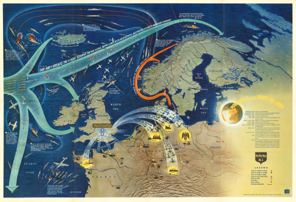
S.P.K., Vichy French Churchill Octopus Map, 1942£ 2,500.00
-
Anonymous, Portuguese WW2 Propaganda, 1943 c.£ 650.00
-
-
Close
Search Inventory
Our entire inventory of over 10,000 antique and vintage maps is now available to browse by region, date, cartographer, and subject


Join our mailing list
* denotes required fields
We will process the personal data you have supplied to communicate with you in accordance with our Privacy Policy. You can unsubscribe or change your preferences at any time by clicking the link in our emails.
![]()